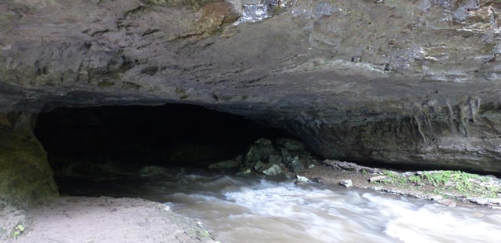
Last week brought seemingly never-ending rainstorms to Sewanee. The downstream effects were dramatic. Crow Creek, running from the entrance to Buggytop Cave, south of Sewanee, was overtopping huge boulders and engulfing trees.

 The water here comes from the sinkhole in Lost Cove and from the many streams that run from the south side of Sewanee. The water’s brown tinge is a melange of woodland tannins, soil erosion, and whatever washes from the streets and houses of exurbia.
Inside the cave entrance, the water’s sounds echoed from walls and the low ceiling. Quite a thunder.
(to hear sound, email subscribers need to click on the post’s title to link to the webpage)
The Buggytop cave entrance is a wide maw, easily walkable when the water is low. One hundred or more feet of limestone cliff extend above the entrance. The cave goes back about a mile into the limestone. According to Gerald Smith and Sean Suarez’s ever-fascinating Sewanee Places, the cave gets its name from the folded appearance of the collapsed rocks inside the entrance. Coincidentally, an abandoned buggy trail from Sherwood into Lost Cove passes not far from the cave entrance. Smith and Suarez also relate that the cave’s accessibility and popularity make it the number one site for local cave rescues. Many a poorly-equipped wanderer has become disoriented after their lights fail, both inside the cave and on the sinuous trail from the road. I was not tempted to join the list of rescuees by attempting a solo passage through the whomping water. Sitting in the presence of the echoing tumult was excitement enough.

Holy cow. I drove through the Ocoee Gorge July 3, and the river was roiling and boiling like angry cafe au lait. I am done with rain for a while.
“angry cafe au lait” . Well done!
Yes, and far worse than a grumpy cappuccino.
My father , Jeannie and I hiked in a few years back in mid-summer after a few days of stormy weather and witnessed better than average flow – but you really hit a peak ! I was surprised to find a pair of green anoles lizards up a tree trunk there on that hike (the last one there with Dad) but the field guide I looked at when we got home showed a finger of the population map through that area. That is my only anole sighting in Tennessee I think. I am always amazed at how the trail over to Buggytop stays muddy even in fairly dry weather and sometimes while traveling along with my own personal swarm of gnats thought the name of place very appropriate.
Yes, the trail was a mud-bath this time too. I’ve seen the anole at the bottom of several coves here but never on the upper slopes or uplands. I wonder if they overwinter in the limestone cracks or under big logs?
Whoa! I liked to sit at the base of that sycamore, in it’s gnarled, mossy roots and write. Looks like today I would have to have rite in the rain paper. And to velcro myself to the tree.
Lashed to the mast like Odysseus.